 modified.jpg)
...You are here: Home >Seven perspectives on Sydney CBD under Clover Moore
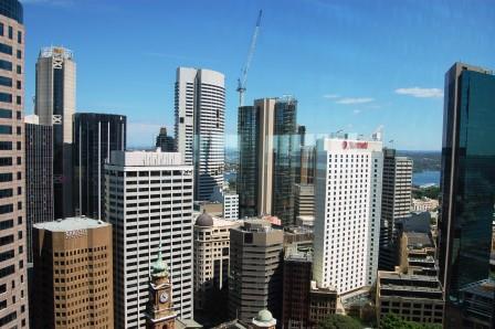
Seven perspectives on the evolution of Sydney CBD under Lord Mayor Clover Moore
A seven-part series originally published in the former online magazine SlowSydney.com
One: Who owns Sydney? Two: We're all environmentalists now? Three: Where's my desk?
Four: The lure of the tram Five: The cycle spin Six: Going underground Seven: Living in the city
Articles One, Two, Three and Four are on the preceding page > here
Five: The Cycle Spin
September 21, 2013 / John Muscat
What are we to make of Sydney CBD's latest cycle policy?
On coming to office in 2011, Premier Barry O'Farrell's State Government was expected to end up at loggerheads with Mayor Clover Moore's Sydney City Council. A law effectively stripping her of a right to sit in state parliament seemed to confirm that impression. But in one regard, things have taken a different turn.
Judging by recent decisions, the Government’s vision for Sydney’s CBD isn’t far removed from the Mayor’s anti-car utopianism. They have joined forces on projects which have always looked impractical from a city-wide perspective, even to the dysfunctional Keneally Labor Government.
First there was the momentous decision to reintroduce trams (light-rail) to the CBD and to pedestrianize a busy section of George Street. This surprising move, amongst others, may have precipitated former Premier Nick Greiner’s departure from the state's infrastructure oversight agency, Infrastructure NSW.
Now the Government has embraced Council’s controversial Cycleway Network, or at least its ‘city centre’ core. Released this month, the Government’s City Centre Access Strategy ‘demonstrates how light rail, buses, trains, cars, taxis, pedestrians and cyclists will interact in the heart of Sydney’. If it’s about putting cyclists on a par with drivers, that sounds like a major objective of Council’s Cycling Strategy and Action Plan 2007-2017. ‘Making cycling an equal first choice transport mode’ is one of the Mayor’s animating principles.
Council’s Action Plan envisages a grid of mainly ‘bi-directional separated cycleways’ (bike lanes) crossing the CBD on a north-south axis along Castlereagh, Pitt, Kent and Chalmers Streets and the Harbour Bridge, and on an east-west axis along King and Liverpool Streets and the Cahill Expressway. Cyclists would reach every corner of the CBD, and link up with cycleways and ‘shared paths’ to inner-city Pyrmont, Darlington, Redfern, Woolloomooloo and beyond. Only the separated lanes along sections of Kent, King and College Streets have been completed. Essentially, the Government has endorsed the same network, but the bike lane in College Street will be ‘decommissioned’. That was the only sour note for an otherwise delighted Mayor Moore.
Her relief is understandable. Council has spent around $12 million – including $4.9 million now wasted on College Street – and allocated a cycleways budget of $76 million over the next decade. But work has progressed in fits and starts. In earlier times Roads Minister Duncan Gay looked like a cycle-sceptic, claiming some of the paths were badly sited. Now they are his problem as much as the Mayor’s.
Mr Gay’s doubts prompted the Sydney Morning Herald to lodge a FOI request for post-2010 Departmental reports on the CBD cycleways. This produced a ‘gotcha’ piece by reporter Jacob Saulwick quoting bits of RTA briefings like this: ‘Given that the bi-directional paths do not occupy previous general traffic lanes [but previous parking space], no significant delays to other road users arising from the cycleways have occurred’.
Saulwick answered the wrong question, though. If the problem is congestion, why weren’t the parking spaces converted to general traffic lanes instead?
Despite many protestations, neither the Herald, nor the Mayor, nor the Greens care about traffic congestion. They have an ideological aversion to motor vehicles, and a commercial or political need to deliver street-level amenity to their inner-city readers and constituents. City Council has a lower level of car ownership than the Greater Sydney average, 60 as against 85 per cent, and a higher proportion of walking or catching public transport to work, 56 as against 24 per cent. The Government’s Access Strategy adds that ‘at least half of all weekday trips to the city centre are from adjacent inner-city areas with about 30 per cent from middle ring suburbs and less than 20 per cent from the outer metropolitan regions’.
But despite the claims, this isn’t about a serious shift to cycling as a transport mode. According to Connecting Our City, Council’s 2012 transport plan, only 0.8 per cent of commuters to Central Sydney travel by bike. That hardly warrants millions of dollars of cycling infrastructure. Council’s website resorts to shopworn statistical tricks to try to make its case. For example this claim: ‘More and more Sydneysiders are riding bikes for transport, with a 100% increase over the past 3 years’ (ie cyclists have advanced from a tiny fraction of travellers, to a tiny fraction double the size). Or this one: ‘Twice as many are riding bikes for transport than the national average’ (ie the tiny fraction of cyclists is twice as large as the even tinier fraction of inter-state cyclists).
The plan’s target of increasing ‘the number of bicycle trips made in the City of Sydney, as a percentage of total trips, from less than 2% in 2006 to 5% by 2011, and to 10% by 2016’ is probably a pipe dream. If it is met, that will likely be due to the scorched-earth policy of turning drivers away.
So the continuing focus on bicycles is curious. The fact is, bicycle trips to the CBD are a minuscule proportion of all trips and likely to remain so. This hardly changed over the eleven years to 2012. Cars represent a relatively minor and declining percentage of trips, even if they account for most vehicle movements. Buses account for very few peak hour vehicle movements. Now as always, people within Sydney’s CBD walk, because it’s a relatively compact space compared to other modern CBDs, easily traversable on foot.
And for walkers, Sydney is not too bad, whatever the weather. It is now possible, in fact, to walk underground all the way from George Street opposite Event Cinemas to the Mid-City Centre in Pitt Street Mall through various arcades, malls and Town Hall Station. Other stations like Wynyard and Martin Place and some office-retail complexes also link up to underground passageways, malls, arcades and food courts. Pedestrians can cover substantial distances without rising to the surface.
In contrast, traffic congestion remains a frustrating experience for peak hour commuters. There is little hard evidence that bike lanes will do anything but make things worse.
Six: Going Underground
October 30, 2013 / John Muscat
Just how far you can walk in Sydney’s CBD without having to stop for a traffic light?
In 1982 Brian and Barbara Kennedy published the little known book Subterranean Sydney: The Real Underworld of Sydney Town, a guide to the system of functioning and derelict drainage, sewerage, water, telephone, mining, railway, defence, electricity and gas, and pedestrian and road tunnels under the city’s surface (it’s posted in full on the Sydney Architecture website). The book is packed full of arcane detail, but the chapter on pedestrian tunnels offers some intriguing glimpses of an alternative present.
Having described the tunnels around Wynyard Station, the Kennedys add that “Sydney City Council would like to see this subterranean network extended”. In 1971, they wrote, “the Council put forward a plan for a network of overpasses, arcades, and underpasses around Wynyard Station”. This is followed by references to plans for an improved arcade and pedestrian subway under George Street, a new tunnel under Hunter Street to Australia Square and an underpass under Clarence Street from Wynyard. While some of these exist today, others got no further than the drawing board.
In those days, pedestrian tunnels represented consensus thinking amongst officials and planners, linking City Circle stations, other transport facilities like car parks, and heavily patronised destinations such as department stores. This makes a lot of sense: Sydney CBD is too compact to justify rail infrastructure along the lines of the London Underground or New York Subway, but dense enough to generate substantial pedestrian traffic. Underground walkways were a sensible idea, yet apart from isolated routes radiating to blocks around the railway stations, an integrated network dropped off the agenda.
It’s not that walking has gone out of fashion. Under Lord Mayor Clover Moore, Sydney Council campaigns zealously for ‘walkability’ over the entanglement of vehicles and pedestrians. As she told the Planning Institute in March, “the creation of compact, walkable and liveable cities is essential …”
But there are problems. “Noise, congestion and disruptions caused by slow changing traffic lights, narrow footpaths and construction work are off-putting,” wails Council’s website, “it should be easy to wander around Sydney to do errands, visit clients, meet friends, window shop, stretch your legs, or just meander along”. In pursuit of this idyll, the Mayor has pushed disruptive, expensive and probably futile schemes to sweep vehicles off Sydney’s streets: bike paths attracting less than one per cent of city commuters, and light-rail on routes already serviced by buses that produce a measly 8 per cent of peak-hour vehicle movements.
Yet as many Sydneysiders know, the city is already provided with some pretty impressive underground walkways that could form the nucleus of a more extensive network. Consider the opportunities that already exist for walking in central Sydney without traffic lights and construction work.
EXAMPLE 1: from Bathurst Street to the Pitt Street Mall
Starting at the precinct around Town Hall, pedestrians can go underground at Pavilion Plaza, an arcade under the HSBC Building near the corner of George and Bathurst Streets. This leads north to the Town Hall Station concourse, from which you can head off in many directions, including to the food court under the Galeries on the corner of George and Park Streets, or continue north into the Lower Ground Floor of the Queen Victoria Building. This very long (and crowded) stretch eventually gets you to the large food court beneath Myer, and then to the Mid-City Centre, with an exit into the middle of Pitt Street Mall.
A couple of hundred metres north, at the corner of Pitt and King Streets, beside the Theatre Royal, pedestrians can join the underground walkways centred on Martin Place Station, initially through the circular arcade under the MLC Centre.
EXAMPLE 2: Skyways
You can walk above the roads as well as below them. Another way to the MLC Centre, for those using the above route, is by escalator from Myer’s food court up to the store’s Level 1, where an enclosed footbridge crosses east over Pitt Street Mall to Westfield’s Level 3. Once there a left turn north leads into an arcade called Glass House and another enclosed footbridge over King Street into the MLC Centre.
For those headed east, Westfield’s Level 3 has an exit at the corner of Castlereagh, Market and Pitt Streets, while a different enclosed footbridge from Level 4 crosses over Castlereagh Street into David Jones with an exit in Elizabeth Street, opposite St James Station on the edge of Hyde Park.
(Apparently there used to be underground access from the lowest level of David Jones to St James, but that seems to have been sealed).
EXAMPLE 3: The Wynyard Routes
Continuing from the route in Example 1, a corridor from the MLC Centre arcade leads north to the walkway-cum-arcade under Martin Place, with the railway station at the eastern end. Travelling east, the walkway branches off to exits labelled North Elizabeth Street and South Elizabeth Street. Further east it branches off to North Phillip Street and South Phillip Street. The North Elizabeth Street exit is near the corner of Elizabeth and Hunter Streets, opposite Chifley Square.
This exit is two blocks east of the Hunter Connection in Pitt Street, the nearest entry to the underground walkways centred on Wynyard Station. Hunter Connection’s lower ground level proceeds westwards from an arcade to a walkway under George Street, ending at the Wynyard Station concourse. At its northern side, the concourse joins MetCentre, an arcade which continues underground north to Jamieson Street, three blocks short of Circular Quay. Other exits from the concourse are to George Street and westward to an escalator which ascends in … York Street!
THE UNDERGOUND CITY: A PROPOSAL
In short, the city can be traversed underground, or at least without confronting vehicles, all the way from south of Bathurst Street to Chifley Square and mid-Macquarie Street. If the authorities cared to excavate a link from Chifley Square to Pitt Street, just two blocks away, the network would reach northern York Street. An extension further west to Clarence and Kent Streets and Barangaroo South is already in the pipeline. With another short addition from Jamieson Street, it could get to Circular Quay.
All that would be needed is State Government and Council recognition of the network as a component of Sydney’s transport system. Calling it something like Sydney Underground Walkways, they could signpost, colour-code and name the routes, and design a map for distribution online and around the city. Names like Town Hall Walk, Martin Place Walk or Wynyard Walk would do nicely (the proposed walkway from Wynyard to Barangaroo, mostly under Margaret Street, has been tagged ‘Wynyard Walk’).
Aside from improving the lot of pedestrians, such a network could appeal to visitors, matching the success of similar systems overseas. Notable examples are Houston downtown’s Tunnel System, which links 95 city blocks, Toronto’s PATH, Montreal’s RESO (aka La Ville Souterraine) and Singapore’s vibrant network of underground malls and walkways, radiating from Citylink Mall near Marina Bay and the ritzy shopping strip along Orchard Road.
November 24, 2013 / John Muscat
The recent $17 million sale of a ‘trophy penthouse’ in The Residence, an apartment tower facing Hyde Park, points to some dramatic changes in the city.
Most people still assume Sydney’s rich live in places like Mosman or Vaucluse, on the lower north shore and the eastern suburbs. But increasingly the city is turning into an enclave where the well-heeled don’t just work and socialise, but also live.
Without resorting to that clunky word ‘Manhattanisation’, this is one of four trends sweeping the CBD. Others are the retail core’s rise to international status and mall-style shopping, emergence of an Asian sub-CBD south of Goulburn Street, and conversion of the ‘zone-in-transition’ to office and apartments towers. The last one calls for some explanation.
According to the ‘core-frame model’ of the CBD, as developed by urban geographers, businesses competing for the highest rents, like upmarket retail and professional offices, concentrate in core blocks while more marginal activities are relegated to peripheral blocks. While these outer areas tend to consist of low grade and sometimes dilapidated building stock, their owners have little incentive to upgrade them. They will eventually be sold and demolished for redevelopment, absorbed by the more dynamic and expanding retail and office cores.
Until then they are a zone-in-transition, often run-down and seedy, featuring rows of pawn shops, op-shops, charity stores, second-hand and adult bookshops, R-rated cinemas, warehousing and storage space, tobacconists, ‘massage parlours’, reject shops, bespoke tailors, cobblers, back-packer hostels, shop-front jewellers, ethnic supermarkets and other low rent activities.
Sydney used to have a zone-in-transition straddling the lower reaches of Sussex, George, Pitt and Castlereagh Streets from Haymarket and Railway Square up to Bathurst Street and then shifting west up parts of Sussex and Kent Streets. Now it has all but disappeared, replaced by snazzy office complexes, hotels and luxury apartments along the ‘western corridor’ facing Darling Harbour, and a forest of prestige apartments south of Bathurst Street.
Looming over the skyline, these include Meriton Tower, The Summit and Sun Tower in George Street, Lumiere in Bathurst Street, World Tower, The Waldorf and Radisson in Liverpool Street, Meriton Serviced Apartments, Fraser Suites and Adina in Kent Street, Emporio Apartments, Landmark Apartments, Windsor Plaza and Maestri Towers in Sussex Street, The Shed in Goulburn Street, Quest World Square in Cunningham Street, The Miramar, Hordern Towers, Century Tower, Princeton and another Meriton in Pitt Street, and The Peak in Quay Street (Haymarket). And they come with a price tag befitting their fancy names. For a two-bedroom apartment in World Tower, expect to pay $1,010 a week, more than double Sydney’s median rent of around $420.
The transitional zone used to occupy the space between the core and the inner-city industrial belt, but this residential outcrop has been accompanied by the departure of maritime functions from Darling Harbour, and of light industry from places like Pyrmont, Ultimo, Chippendale, Redfern and Surry Hills.
One of the drivers of this change is a growing desire to live in the city. Sydney Local Government Area, which covers the CBD and surrounding suburbs, has experienced something of a population boom over the last decade, roughly coinciding with Mayor Clover Moore’s time in office. It may surprise some people, considering high rates of settlement in the western suburbs, but Sydney LGA has amongst the largest growing populations in New South Wales. Of the 42 LGAs across Greater Sydney, it ranked seventh for population growth between 2006 and 2011. In 2010-2011, it came in third amongst all 152 New South Wales LGAs for size of growth, behind Blacktown and Parramatta. Statistics show that people moving into Sydney LGA tend to have higher incomes and educational qualifications than the average.
The Mayor is an active promoter of residential construction, warmly embracing the former government’s target of an additional 55,000 dwellings in Sydney LGA by 2035 (the population is forecast to rise by 50 per cent over that time, to 280,964). In part, this reflects her green predilection for a small urban ‘footprint’, reining in Sydney’s peripheral expansion.
But political advantages can’t be ruled out. The Mayor and her team draw support from residents, offering more and better ‘environmental’ amenity. This helps counter the votes of business owners, also enfranchised in council elections, who tend to prefer Liberals or other business-friendly candidates. The proportion of business owners registering to vote has fallen recently.
Presently, the CBD is ringed by some huge residential development projects, of which the Mayor is a vocal champion. Green Square in Alexandria will deliver up to 20,000 new residential units, Central Park in Haymarket and Barangaroo South (both in the old transitional zone) another 3,000 and 800 respectively, and Harold Park near Glebe another 1,250. Just recently, 159 of the apartments planned for Barangaroo were sold out within hours, including one for $10.5 million.
In its latest phase, though, the residentialisation of central Sydney penetrates beyond the ring projects, beyond the transitional zone, right into the CBD’s office and retail cores. Lingering effects of the financial crisis on white collar employment, combined with practices like ‘hot-desking’ which ration the use of workspace, have nudged the office vacancy rate toward 10 per cent. According to real estate firm LandMark White, “the only thing that could save the CBD office market over the next five years will be residential conversions”. Hardest hit are B and C grade buildings without a flashy green rating.
Conversion of office towers for apartments is now a well established trend. The large block at 34 Hunter Street is to be made over for units, as well as the former Packer headquarters in Park Street, the Coca Cola Amatil building and Goldfields House in Circular Quay, office blocks at 227 and 130 Elizabeth Street, and 570 George Street, amongst others. And purpose-built apartments are making an appearance in the CBD core, notably Fife Capital’s 32-storey ‘York & George’ at 383 George Street and the 70-storey Greenland Tower in Pitt Street, billed as ‘Sydney’s tallest residential tower’.
“Residential living is the thing that’s most attractive to developers currently and it’s wonderful to see people living right in the city,” says Mayor Moore in a Sydney Morning Herald report, even while professing support for “financial, legal and business employment”. The report has her explaining that the number of people living in the CBD has risen from 4,767 in 1991 to 22,755 in 2011, and is forecast to reach 34,000 by 2030.
Articles One, Two, Three and Four are on the preceding page > here
Like to comment? email thenewcity@live.com.au
More articles are here and follow us on twitter or request our free email updates here.
Copyright© 2017, The New City. All rights reserved.